Maps of Britannia from 500 to 700 AD
When we speak of the period between 400-700 AD, we will define “Britons” as the Indigenous Celtic population of Britain, Romanized to some degree. “Anglo-Saxons” will refer to Germanic tribes from Northern Europe who migrated to Britain and established new kingdoms. At this time, Britons were largely pushed westward by the Anglo-Saxon expansion, while the Anglo-Saxons formed their own distinct society with different customs and language.
The key differences between Britons and Anglo-Saxons can be found in their ethnicity, culture, language, and political structure. As stated in the previous paragraph, Britons were Celtic people, while Anglo-Saxons were Germanic tribes, including Angles, Saxons, and Jutes. Britons had a Romanized culture with influences from Roman law and architecture, while Anglo-Saxons had a more tribal culture with distinct customs and traditions. Britons primarily spoke a Celtic language, while Anglo-Saxons spoke Old English, a Germanic language.
It is important to note that the Anglo-Saxon settlement of Britain was not a complete replacement of the British population, but rather a process of integration and assimilation, with some Britons remaining in Anglo-Saxon society. The term “Anglo-Saxon” is used to refer to the collective group of Germanic settlers in Britain, combining the names of the Angles and Saxons. The historical period between 400-700 AD is considered a time of meaningful change in Britain, marked by the decline of Roman influence and the rise of Anglo-Saxon power.
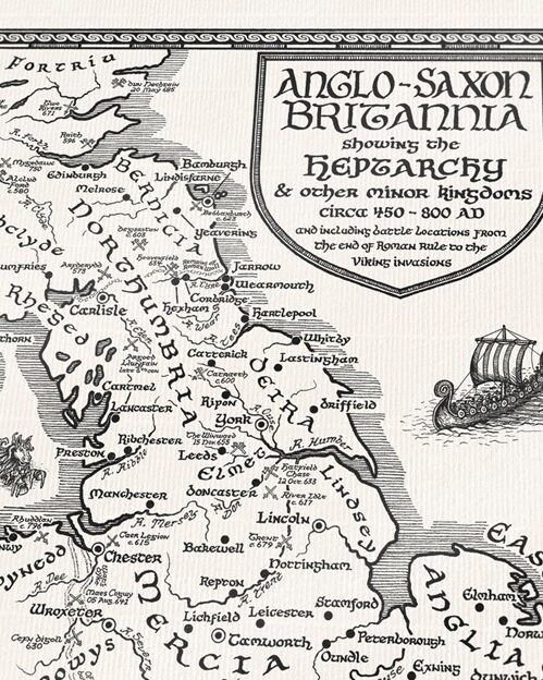
A map showing where Britons and Anglo-Saxons lived in Britannia between 400-700 AD would depict the Britons primarily concentrated in the western regions of the island, including Wales, Cornwall, and parts of Scotland, while the Anglo-Saxons would be situated across the eastern and southern areas, with major settlements in kingdoms like Kent (Jutes), East Anglia (Angles), and Wessex (Saxons).
1. Kent was settled by the Jutes. Ethelbert of Kent was the first Anglo-Saxon king to be converted to Christianity, by St Augustine around 595 AD.
2. Mercia stretched over the Midlands and was settled by the Angles. Their best-known ruler, Offa, built Offa’s Dyke along the border between Wales and England.
3. Northumbria, also settled by the Angles, was where the monk Bede (c. 670-735) lived and wrote his Ecclesiastical History of Britain.
4. East Anglia, also settled by the Angles, includes North Folk (modern Norfolk) and South Folk (modern Suffolk). The Sutton Hoo ship burial was found in East Anglia.
5. Essex (East Seaxe)was settled by the Saxons from northwest Germany who sailed up the River Thames.
6. Sussex was also settled by the Saxons. The name Sussex comes from the Old English words Suð Seaxe, which means “South Saxons.”
7. Wessex (West Saxons), Bede stated the original name for the West Saxons was the Gewisse. The change in name from the Gewisse to the West Saxons seems to have taken place in the latter part of the seventh century. The Gewisse, like the ‘Cantwara’ (Kent-men) and the ‘Meonwara’ of Hampshire were political units, not tribes.

Britain around the year 540. Anglo-Saxon (Angles, Saxons, Jutes) kingdoms’ names are colored red. Brittonic (Celts) kingdoms’ names are colored black. Placements of people are based primarily on information in the Anglo-Saxon Chronicle and Lloyd’s History of Wales, Vol. I. [Source: Wikipedia]

Map of the Brythonic (Celts) and Anglo-Saxon (Angles, Saxons, Jutes) kingdoms, c. six hundred, by Mike Christie. [Source: Wikimedia Commons]
What was to become Northumbria started as two kingdoms, Deira in the south and Bernicia in the north. Conflict in the first half of the seventh century ended with the murder of the last king of Deira in 651, and Northumbria was thereafter unified under Bernician kings. [Source: Wikipedia]

Northumbria around 700 AD

